Are anti-erosion measures fair play for farmers in Wallonia?
In response to criticisms related to the complexity of the Common Agricultural Policy (CAP) and its disconnection from reality, the European Commission has proposed the implementation of national strategic plans, leaving it up to the Member States (or regions) to define the details of the measures to be implemented for farmers to get direct payments. This is a key feature of the new CAP, with serious impacts on the level playing field at EU level for farmers. The implementation of GAEC5 is shedding lights on this new reality, with farmers in Wallonia paying the high price.
Articles 12 and 13 of Regulation 2021/2115 of the Common Agricultural Policy (CAP) deal with conditionality, i.e., the set of obligations relating to good agricultural and environmental conditions (GAEC) that farmers must comply with to access funds from the first pillar of the CAP. The national plans submitted by the Member States must specify the details of these measures, indicating concretely how they intend to apply them to their farmers. Although this new approach, initially presented as a common-sense evolution in response to the failure of multiple attempts to simplify the CAP, it nonetheless presents a major obstacle. As far as basic aid is concerned, it places European farmers in the face of variable rules, with sometimes strongly divergent economic and agronomic impacts.
Each of these GAEC measures aims to address common environmental, health or animal welfare challenges, with the ambition of having a positive impact on a very large scale across the entire territory of the European Union, mobilizing a collective effort of all EU farmers. These actions must complement other specific measures and financed within the framework of eco-schemes or agro-environmental measures. All national (or regional) strategic plans are known. Even, many Member States are already preparing to adjust their initial plan, with the insights of one year of implementation. It is therefore useful to examine the details, analyzing not only their but also their socio-economic impacts. It appears that national or regional administrations are sometimes just as – if not more – creative than the European administration in terms of complexity, sometimes leaving farmers isolated in the face of an increased risk of inequitable treatment, without any real European debate.
In this regard, the analysis of GAEC 5 is particularly significant. Faced with the important challenge of soil erosion, the cross-compliance rule in the EU regulation states that it is necessary to “manage soil work in order to reduce the risk of degradation and erosion, taking into account the slope.” The objective to be pursued is that of “minimal land management reflecting specific local conditions in order to limit erosion.”
It plays an important role at the European level, alongside GAEC 4 and 6, in combating this phenomenon that affects the long-term fertility of soils. All other parameters are now the responsibility of the Member States or regions. They are the subject of the comparative study below. Previously, despite some flexibility, most of the details were fixed by a delegated act of 2014, which established the basic principles of minimum soil cover, the minimum area of farms that must be covered to comply with this GAEC, crop rotation or reduced tillage.
The challenge of erosion throughout the European Union
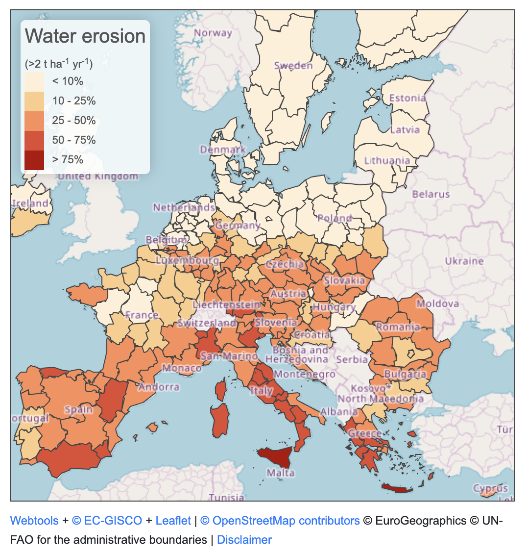
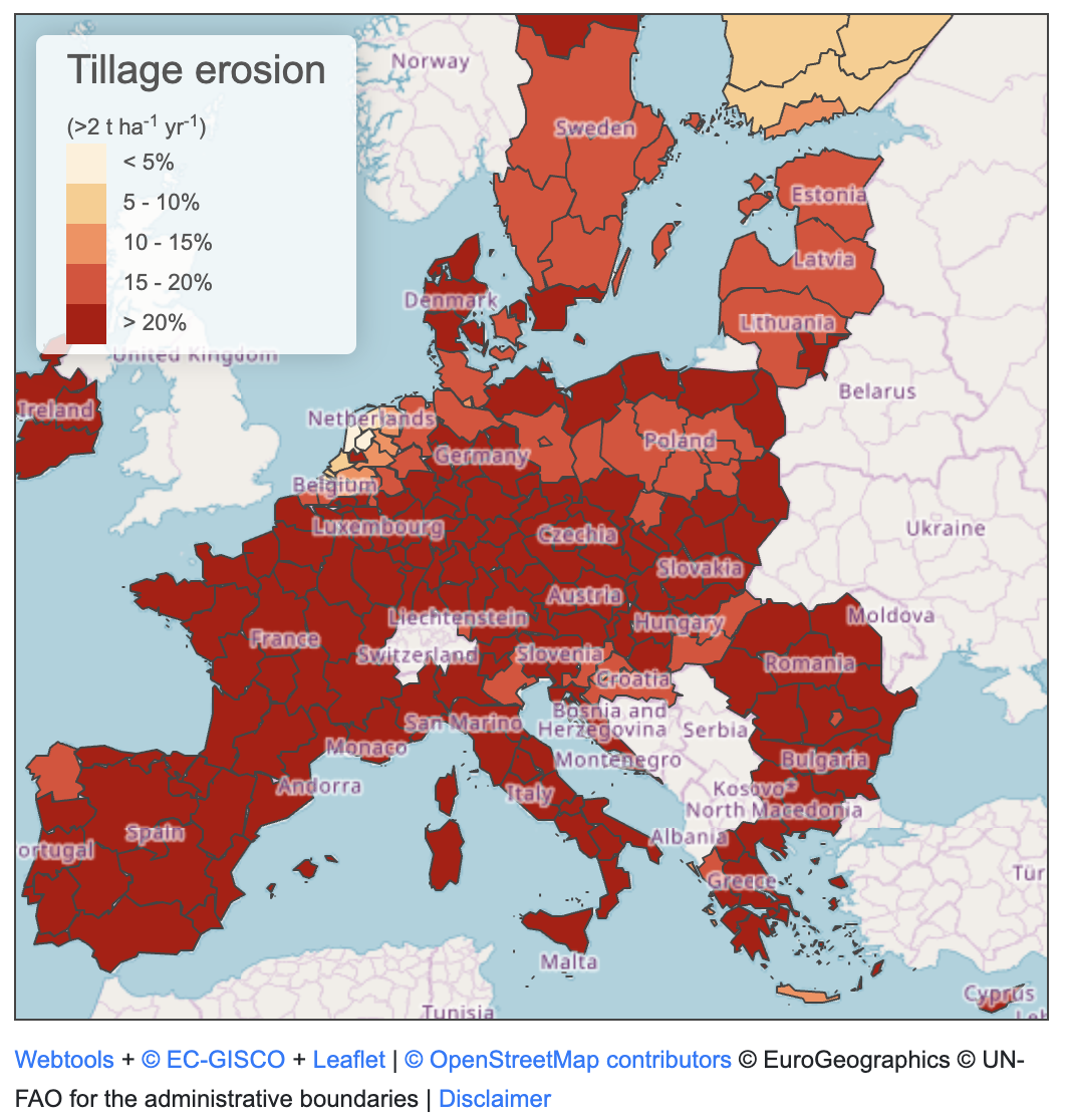
It is important to recall that erosion is a challenge affecting all regions of the European Union, without exception, as shown by the recently published data from the Joint Research Centre in the context of discussions on soil strategy. By far, the most significant vector of soil erosion, both quantitatively and geographically, is water. This affects most Member States, with a stronger impact on Mediterranean countries and Central European countries. Erosion caused by ploughing also has a very large geographical impact, affecting all Member States, with a lesser impact in part of Belgium, the Netherlands, some regions in northern Germany and Poland.
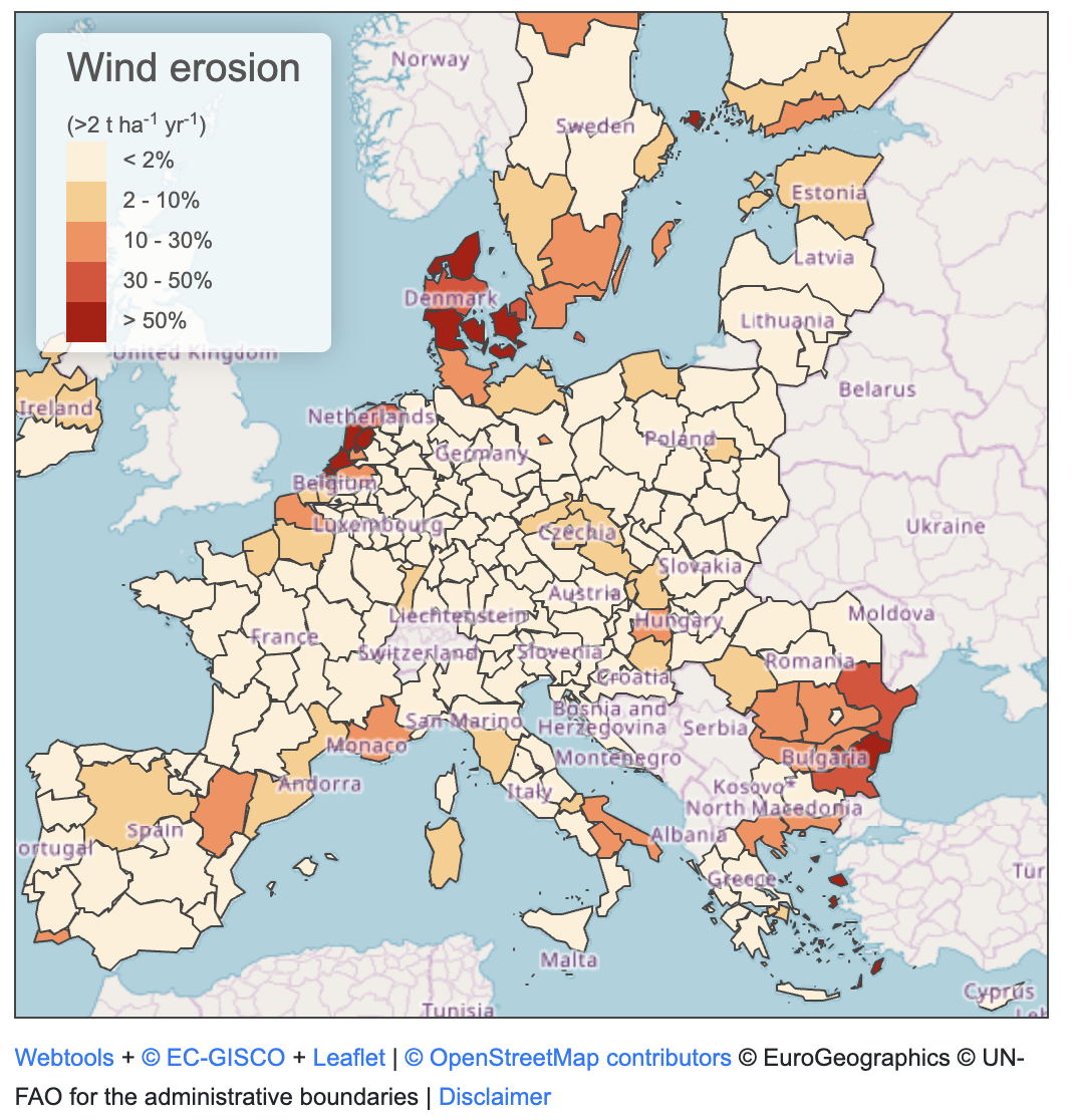
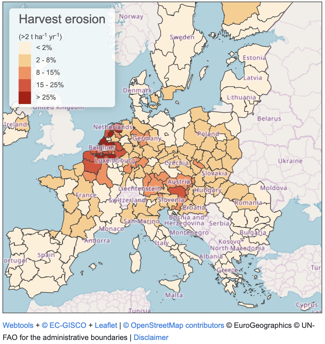
As for wind erosion or erosion caused by harvesting, they are indeed more localised: the former occurs on the northwest coast, some regions of the Black Sea, southern Italy, or northern Spain, and the latter occurs in crop areas where uprooting is involved. The latter represents a much smaller part of the erosion phenomenon at the EU level. Measures planned under GAEC5 have limited relevance regarding harvest erosion. Combating this requires technical means aimed at limiting the amount of soil carried away during the harvesting of potatoes or beets through gentle digging or the use of specific conveyor belts.
Diverging ways to define targeted areas
In the case of Wallonia, the GAEC5, which determines the granting of all aid to farmers, is particularly detailed and expensive. Wallonia’s approach is very different from that of the majority of other Member States. We will analyse it in detail.
One substantial difference lies in the criteria used by Member States to define the areas to take specific actions. The vast majority of Member States (BG, EE, EL, ES, FR, HR, IT, CY, LV, LT, HU, MT, PL, PT, SI) only mention the “slope” of the soil as a criterion for defining intervention areas and almost always refer to areas with a slope greater than 10%.
Regarding other national plans, the criteria are, however, different. Generally, they are related to differentiated slopes or measures that apply to all areas, regardless of their erosion risk.
For example, Austria’s strategic plan refers to a soil slope greater than 10% but also prohibits agricultural machinery from working on frozen, water-saturated, flooded, and snow-covered soil. Ireland refers to slopes greater than 15% and 20%, but also proposes criteria for all meadows. Plowing of all meadows is prohibited between October 16th and November 30th. For the Netherlands, measures exist for slopes greater than or equal to 2% and greater than 18%. And for Slovakia, specific measures for areas severely threatened by water or wind erosion are mentioned, without specifying criteria. The measures apply to slopes greater than 3%. Finland, Denmark, and Sweden introduce criteria related to the proximity of soils to watercourses.
The Wallonia Region, on the other hand, stands out for its approach. It identifies three zones (high erosion risk, very high erosion risk, extreme erosion risk) using an equation based on the revised universal soil loss equation (RUSLE), which takes into account the following factors: the rainfall erosivity index, the soil erodibility index characteristic of the soil type and its properties, and the topographical factor combining slope length and steepness.
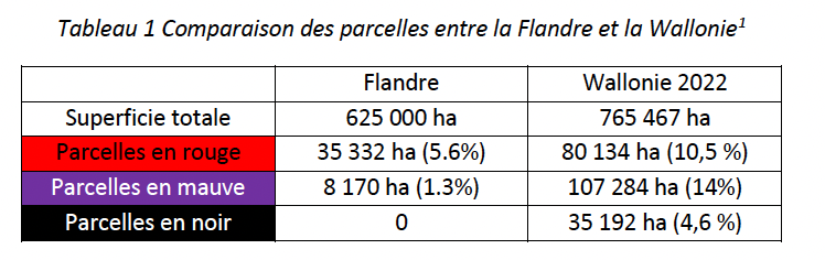
The only national plans that, along with Wallonia, identify different territorial zones with differentiated erosion risks based on multiple criteria are those of Flanders, Germany, Luxembourg, and the Czech Republic. However, these Member States use this tool with significant differences to be taken into account compared to the plan of Wallonia.
The strategic plan of the Flemish Region also provides that “the sensitivity to erosion of a plot is determined based on a calculation model of the average annual potential erosion per hectare using the Revised Universal Soil Loss Equation (RUSLE). Thus, slope, slope length, and soil type are taken into account. There are six erosion sensitivity classes: very high (purple), high (red), medium (orange), low (yellow), very low (light green), and negligible (green). But the impact of this formula in Flanders is marginal compared to that for Wallonia, according to the respective simulations carried out by the Wallonian (FWA) and Flemish (Boerenbond) agricultural organisations (1).
The German strategic plan delegates the designation of erosion risk zones to the Länder, based on uniform criteria, such as soil erodibility factor, slope factor, rainfall and surface runoff erosion factor, and wind erosion risk. The Czech strategic plan identifies several erosion risk zones based on the following criteria: slope length and steepness, structure and texture of the arable layer, soil organic matter content, soil erosion sensitivity, protective effect of vegetation, effectiveness of anti-erosion measures, and soil profile permeability.
Finally, the Luxembourg strategic plan uses a methodology based on multivariate statistical learning (machine learning) for arable land for classifying erosion risk zones. The calculation of potential erosion from RUSLE is only used for grasslands. In addition, there are measures for all agricultural land, for example, existing retention terraces must be maintained on the entire UAA (in arable land, permanent grassland, and permanent crops).
Ambition divide: various approaches for the same measure
As for intervention measures, there are numerous ones. The most common ones are related to soil work restrictions, such as the prohibition of plowing during certain periods. Twenty national plans provide for such measures (AT, BE-FL, BE-WA, CZ, DE, DK, EE, IE, FR, IT, CY, LT, LU, HU, MT, NL, RO, SI, SK, SE). In addition, 13 strategic plans (AT, BG, DE, EE, EL, ES, FR, HR, LV, MT, PL, PT, RO) include measures on the orientation of soil work relative to slope. Twenty-three strategic plans (AT, BE-FL, BE-WA, BG, CZ, DE, DK, EE, IE, EL, FR, HR, IT, LV, LT, LU, HU, NL, PL, SI, SK, FI, SE) include measures related to vegetation cover.
In addition to these common measures, many Member States or regions are identifying other measures to combat soil erosion. For example, the “anti-erosion strip”. Denmark, Finland and Sweden refer to a buffer strip along watercourses with a ban on fertilisation, spraying, and soil work on a minimum width of three meters (six for Sweden), a measure that also meets GAEC4, but which they also consider as an anti-erosion measure. Germany and the Czech Republic mention buffer strips as an anti-erosion measure, but do not specify their length, with Germany leaving the details of the measures to the Länder. The Luxembourg strategic plan provides for the mandatory installation (except in the case of meadows) of anti-erosion grass strips with a minimum width of 3 meters in areas with a high and medium risk of erosion. France and Austria also provide for vegetated strips, with a minimum width of 5 meters in both cases, as an anti-erosion measure.